


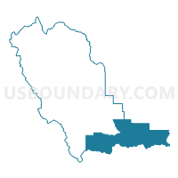
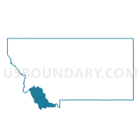
Precinct 4, Beaverhead County, Montana
About
Outline

Summary
| Unique Area Identifier | 611826 |
| Name | Precinct 4 |
| County | Beaverhead County |
| State | Montana |
| Area (square miles) | 875.61 |
| Land Area (square miles) | 857.60 |
| Water Area (square miles) | 18.01 |
| % of Land Area | 97.94 |
| % of Water Area | 2.06 |
| Latitude of the Internal Point | 44.61609330 |
| Longtitude of the Internal Point | -112.11461410 |
Maps

Graphs
Select a template below for downloading or customizing gragh for Precinct 4, Beaverhead County, Montana


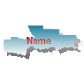
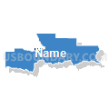


Neighbors
Neighoring Voting District (by Name) Neighboring Voting District on the Map
- Voting District 033001, Clark County, ID
- Voting District 033003, Clark County, ID
- 6 Island Park Voting District, Fremont County, ID
- Precinct 3, Beaverhead County, MT
- Precinct 5, Beaverhead County, MT
Top 10 Neighboring County Subdivision (by Population) Neighboring County Subdivision on the Map
- Dillon CCD, Beaverhead County, MT (7,880)
- Madison Valley CCD, Madison County, MT (3,029)
- Island Park CCD, Fremont County, ID (1,492)
- West Clark CCD, Clark County, ID (904)
- Lima-Centennial Valley CCD, Beaverhead County, MT (375)
- Virginia City CCD, Madison County, MT (285)
- East Clark CCD, Clark County, ID (78)
Top 10 Neighboring Place (by Population) Neighboring Place on the Map
Top 10 Neighboring Elementary School District (by Population) Neighboring Elementary School District on the Map
Top 10 Neighboring Secondary School District (by Population) Neighboring Secondary School District on the Map
Top 10 Neighboring Unified School District (by Population) Neighboring Unified School District on the Map
- Fremont County Joint School District 215, ID (12,140)
- Ennis K-12 Schools, MT (3,482)
- Clark County School District 161, ID (982)
- Lima K-12 Schools, MT (508)
Top 10 Neighboring State Legislative District Lower Chamber (by Population) Neighboring State Legislative District Lower Chamber on the Map
- State House District 35, ID (43,409)
- State House District 71, MT (10,573)
- State House District 72, MT (9,246)
Top 10 Neighboring State Legislative District Upper Chamber (by Population) Neighboring State Legislative District Upper Chamber on the Map
Top 10 Neighboring 111th Congressional District (by Population) Neighboring 111th Congressional District on the Map
Top 10 Neighboring Census Tract (by Population) Neighboring Census Tract on the Map
- Census Tract 2, Beaverhead County, MT (3,470)
- Census Tract 1, Madison County, MT (3,108)
- Census Tract 3, Madison County, MT (2,003)
- Census Tract 9701, Fremont County, ID (1,492)
- Census Tract 1, Beaverhead County, MT (1,366)
- Census Tract 9501, Clark County, ID (982)
Top 10 Neighboring 5-Digit ZIP Code Tabulation Area (by Population) Neighboring 5-Digit ZIP Code Tabulation Area on the Map
- 59725, MT (7,963)
- 83429, ID (1,048)
- 59739, MT (340)
- 59710, MT (286)
- 59720, MT (191)
- 59724, MT (128)
- 83446, ID (48)